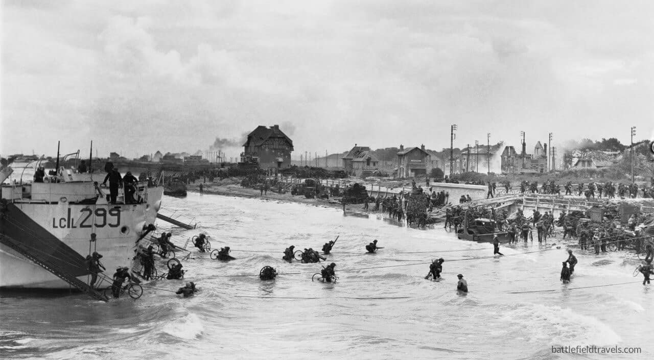
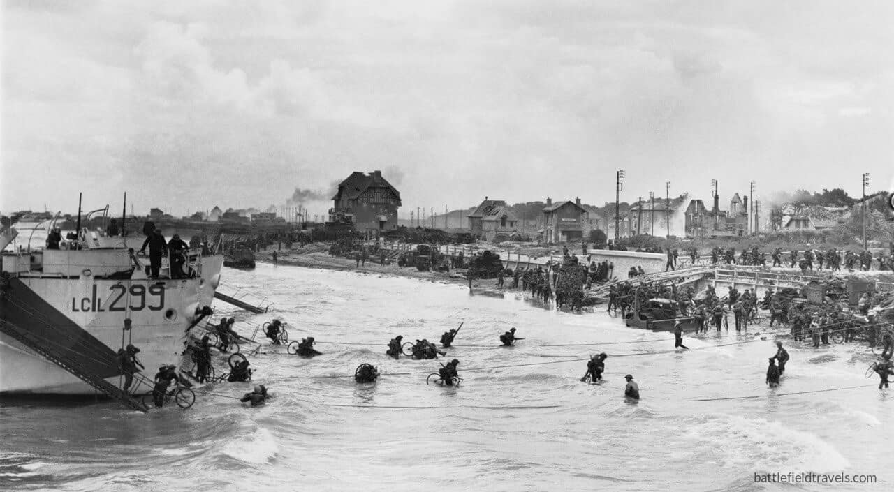
Canada’s bloody D-Day beach — breaking the Atlantic Wall between Gold and Sword!
On 6 June 1944, the 3rd Canadian Infantry Division stormed ashore at Juno Beach, facing some of the strongest German defences in Normandy. Despite heavy casualties, the Canadians forced a breakthrough, secured the coastal villages, and advanced inland to anchor the Allied front.
Key facts
Google Earth map – location of D-Day Juno Beach
Normandy series of battlefield studies
This article is part of a series exploring the D-Day airborne and amphibious battlefields on 6 June 1944 and the immediate aftermath. Click on the hotlinks to open the battlefield study.
Strategic Context – Operation OVERLORD
Allied grand strategy
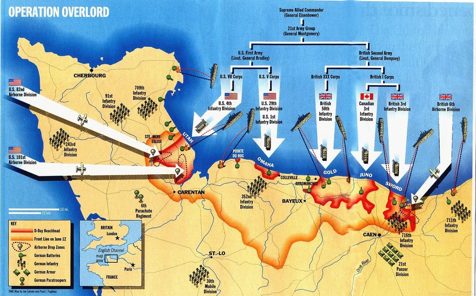
By 1944, the Western Allies had resolved to open a second front in Europe. The Soviet Union had been carrying the main burden of the land war since 1941, suffering immense casualties. Stalin pressed Roosevelt and Churchill for direct action in France to relieve pressure on the Eastern Front. The Anglo-American response was Operation Overlord, the cross-Channel assault designed to break into north-west Europe and defeat Nazi Germany.1Max Hastings, Overlord: D-Day and the Battle for Normandy (London: Michael Joseph, 1984), pp. 29–33.
D-Day operational framework
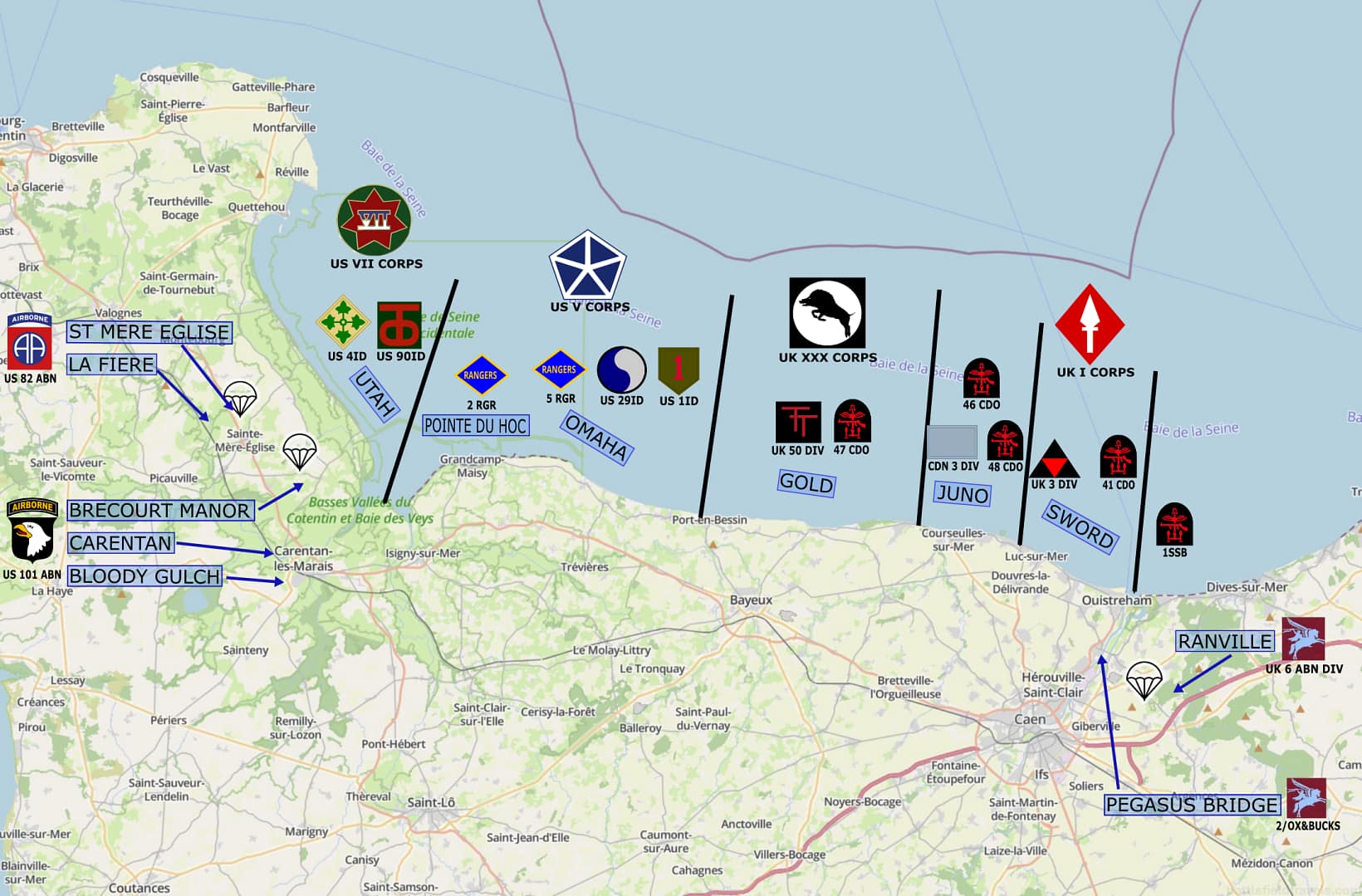
The invasion was planned for early summer 1944, when tides and moonlight favoured large-scale amphibious operations. Supreme Headquarters Allied Expeditionary Force (SHAEF), commanded by General Dwight D. Eisenhower, allocated distinct sectors across a 50-mile frontage of coastline in Normandy. The U.S. First Army would land on the western beaches (Utah and Omaha), while the British Second Army under General Miles Dempsey would assault the central and eastern sectors (Gold, Juno, Sword). Each beachhead had a defined operational purpose in building a continuous lodgement.2Carlo D’Este, Decision in Normandy (London: Collins, 1983), pp. 45–50.
Juno Beach
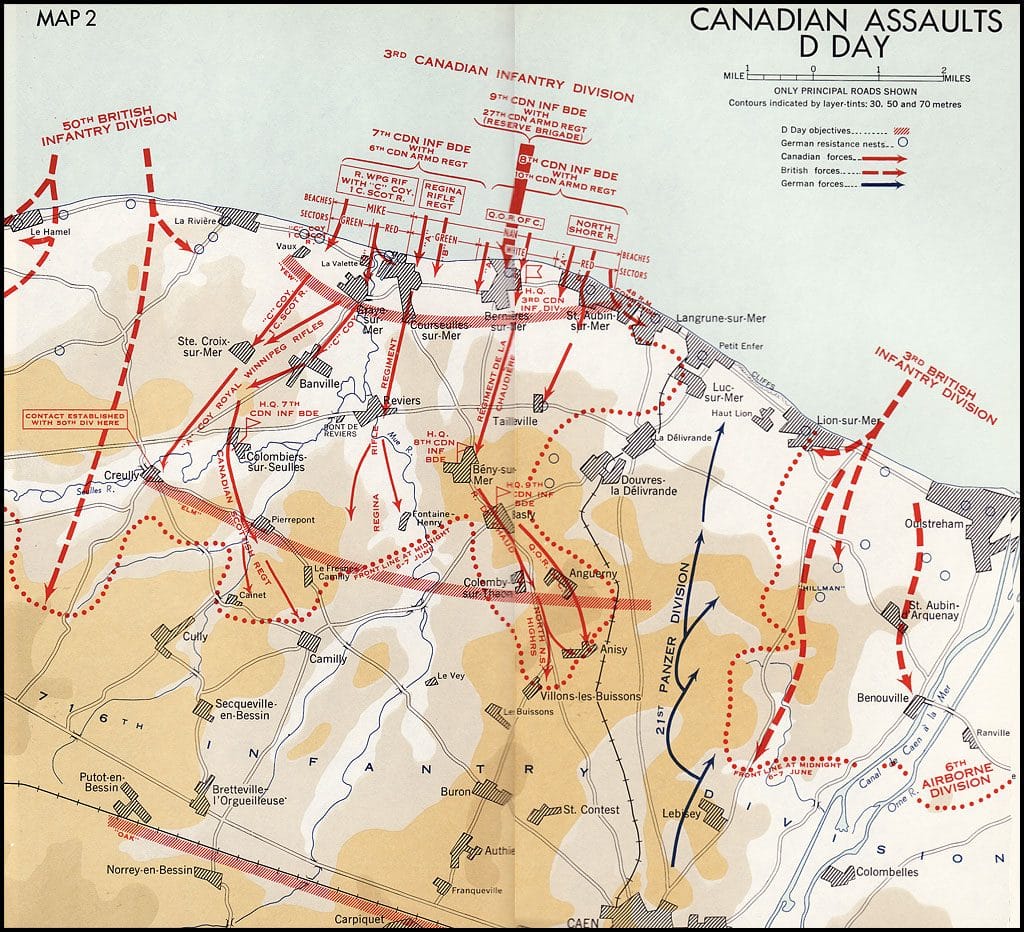
Responsibility for Juno Beach fell to the 3rd Canadian Infantry Division, commanded by Major-General Rod Keller, supported by the 2nd Canadian Armoured Brigade. Their task was to force a landing on the narrow strip of beach between Courseulles, Bernières, and Saint-Aubin, and then drive inland to cut the Caen–Bayeux road before linking up with the British lodgements at Gold Beach to the west and Sword Beach to the east.3C.P. Stacey, The Victory Campaign: The Operations in North-West Europe 1944–1945 (Ottawa: Queen’s Printer, 1960), pp. 58–63.
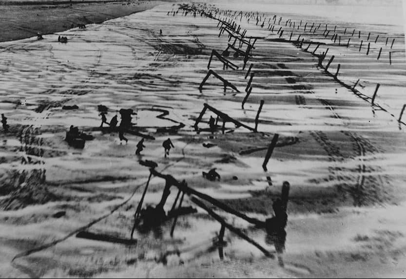
Juno was a difficult beach. The approaches were studded with underwater Belgian gates, mined stakes, and ramps designed to rip open the hulls of landing craft at high tide. Beyond the obstacles, the defenders of the 716th Static Infantry Division, under General Wilhelm Richter, had constructed strongpoints at every village along the shoreline. Each was built around concrete casemates and machine-gun nests, supported by anti-tank and field artillery pieces dug into prepared positions.
Though nominally a second-line formation, the 716th’s positions were formidable, and elements of the 21st Panzer Division were postured further inland, ready to counter-attack once the invasion axis became clear.4Stephen Ambrose, D-Day: June 6, 1944 (New York: Simon & Schuster, 1994), pp. 228–233.
Later H-Hour on Juno
The Canadians would also be landing later than their British and American counterparts. Owing to tidal conditions, H-Hour for Juno was set at 07:35, by which time the defenders had full daylight and a clear view of the run-in to the beach. This, coupled with the constricted approaches and the need to take defended villages immediately upon landing, made the plan an ambitious one.
7th Canadian Brigade was to land on the western sectors, opposite Courseulles, while 8th Canadian Brigade would land to the east, striking Bernières and Saint-Aubin. Once the beachheads were secure, armoured squadrons of the 2nd Canadian Armoured Brigade would push through, leading the advance towards the road junctions and river crossings inland. 9th Canadian Brigade would follow and support or reinforce as required.5John Buckley, Monty’s Men: The British Army and the Liberation of Europe (New Haven: Yale University Press, 2013), pp. 85–87.
Opposing forces

 Allied forces Juno Beach (6-7 June 1944)

3rd Canadian Infantry Division (Maj‑Gen Rod Keller)6C.P. Stacey, The Victory Campaign (1960), pp. 58–63.
7th Infantry Brigade (Brig Harry Foster)
– Royal Winnipeg Rifles
– Regina Rifle Regiment
– 1st Battalion, Canadian Scottish Regiment
8th Infantry Brigade (Brig K. G. Blackader)
– Queen’s Own Rifles of Canada
– North Shore Regiment (New Brunswick)
– Le Régiment de la Chaudière (Quebec)
9th Infantry Brigade (Brig D. G. Cunningham, reserve)
– Highland Light Infantry of Canada
– Stormont, Dundas and Glengarry Highlanders
– North Nova Scotia Highlanders
2nd Canadian Armoured Brigade7Terry Copp, Fields of Fire: The Canadians in Normandy (2003), pp. 22–26.
– 1st Hussars (Sherman DD tanks)
– Fort Garry Horse (Sherman DD tanks)
– Sherbrooke Fusiliers Regiment
 No. 48 (Royal Marine) Commando (Langrune-sur-Mer)
Artillery & Support
– 14th and 19th Field Regiments, RCA (SP guns)
– 12th and 13th Field Regiments, RCA (later waves)
– Royal Canadian Engineers, Signals, Medical, Naval Beach Groups
Naval and Air Support
– Royal Navy Eastern Task Force (Force “J”)8L. F. Ellis, Victory in the West, Vol. I (1962), pp. 150–156.
– RAF and RCAF squadrons providing close air support and interdiction9Max Hastings, Overlord (1984), pp. 123–127.
 German forces – Juno Beach
 German forces – Juno Beach
716. Infanterie‑Division (Generalleutnant Wilhelm Richter)10Niklas Zetterling, Normandy 1944 (2000), pp. 80–84.
– Grenadier‑Regiment 736 (sectors covering Courseulles, Bernières, St‑Aubin)
– Grenadier‑Regiment 726 (adjacent sectors)
– Panzerjäger‑Abteilung 716 (50 mm and 75 mm AT guns)
– Divisional artillery (mostly horse‑drawn, light pieces)
– Coastal artillery detachments in casemates and Widerstandsnester (WN)11Stacey, The Victory Campaig, pp. 60–63.
Local Strongpoints (Widerstandsnester)
– WN 29, 31, 33: fortified positions at Courseulles‑sur‑Mer
– WN 28, 32: defences around Bernières‑sur‑Mer
– WN 23, 24, 27: defences at St‑Aubin‑sur‑Mer12Zetterling, Normandy 1944, pp. 80–84.
– WN 26: Langrune su Mer (Officially part of Sword Beach but allocated to the Canadians at Juno)
21st Panzer Division, Panzer‑Regiment 22 (PzKpfw IV)
– Panzergrenadier‑Regiment 125
– Panzergrenadier‑Regiment 192
– Sturmgeschütz‑Abteilung 200 (assault guns)
Geography & Terrain at Juno Beach
Juno Beach terrain
Juno Beach lay between the British-led Gold Beach to the west and Sword Beach to the east, covering a frontage of roughly eight kilometres from Courseulles-sur-Mer in the west through Bernières to Saint-Aubin in the east. The shoreline consisted of wide tidal flats, up to 500 metres wide at low tide, which exposed assaulting troops to long, open fields of fire. Behind the beaches, small villages lined the coastal road, with stone houses and walled gardens forming natural defensive strongpoints.13C.P. Stacey, The Victory Campaign: The Operations in North-West Europe 1944–1945 (Ottawa: Queen’s Printer, 1960), pp. 64–68.

The seaward approaches added further hazards. Offshore shoals and reefs complicated the run-in of landing craft, particularly opposite Courseulles, where channels forced landings into narrow sectors where the Germans could concentrate their fire. Strong tidal currents influenced timing: the assault was scheduled for a rising tide that would expose obstacles for clearance while still allowing craft to beach successfully.14Terry Copp, Fields of Fire: The Canadians in Normandy (Toronto: University of Toronto Press, 2003), pp.27–30.
Beach obstacles on Juno
The Germans had prepared an integrated defence system. Obstacles were emplaced on the tidal flats, including stakes, ramps, and mined obstacles designed to destroy or cripple landing craft. The beach was reinforced with concrete seawalls in several sectors. Beyond these, lateral streets and the coastal road were covered by machine-gun nests, anti-tank guns, and strongpoints built into civilian houses and hardened bunkers. Inland, the ground rose gently toward the Caen plain, with fields and orchards broken by thick hedgerows — terrain that channelled attacking forces into narrow lanes and offered defenders strong natural positions.15Stephen Ambrose, D-Day, June 6, 1944 (New York: Simon & Schuster, 1994), pp. 233–236.
Pre-assault naval and air bombardment
Air operations
In the early hours of 6 June 1944, RAF Bomber Command and the USAAF targeted coastal batteries and strongpoints along the Courseulles–Bernières–Saint-Aubin frontage. Heavy bombers dropped several thousand tons of ordnance, but results were mixed. Cloud cover and poor visibility meant that many bombs fell inland rather than on the fortified positions. Although the bombardment disrupted communications and forced defenders into cover, most major bunkers and gun positions remained operational at H-Hour.16C.P. Stacey, The Victory Campaign (Ottawa: Queen’s Printer, 1960), pp. 69–71.
Naval gunfire
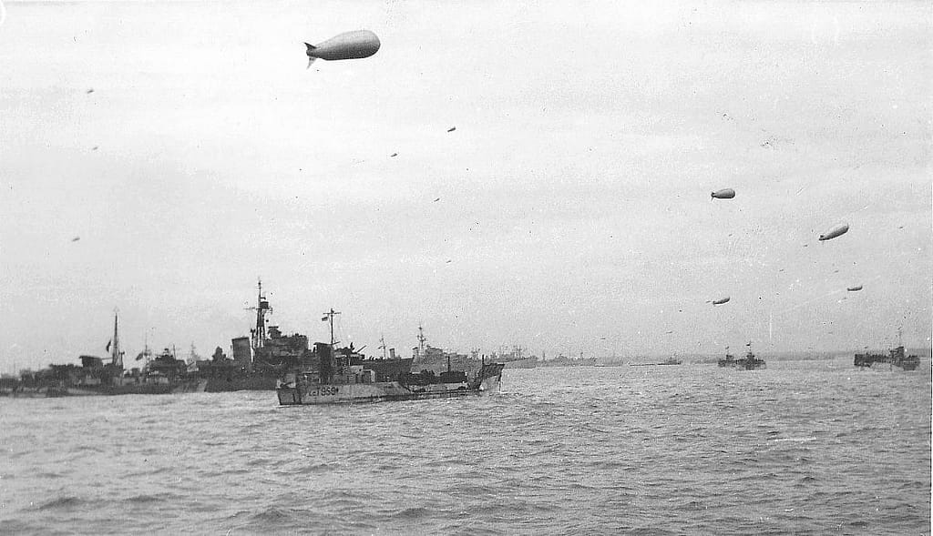
At 05:30 hours, Allied naval units commenced a deliberate bombardment. British cruisers, including HMS Belfast and HMS Diadem, engaged German coastal batteries, while destroyers of the Royal Canadian Navy, such as HMCS Algonquin and HMCS Sioux, closed to deliver more accurate fire. Their primary targets were the concrete casemates housing 75 mm and 88 mm guns, as well as the Widerstandsnester commanding the beach exits. Despite the intensity of the fire, several strongpoints survived intact, notably at Courseulles and Saint-Aubin.17L. F. Ellis, Victory in the West, Vol. I: The Battle of Normandy (London: HMSO, 1962), pp. 156–160.
The naval bombardment lifted shortly before H-Hour. Assault craft of the 7th and 8th Canadian Infantry Brigades began their run-in to the beaches under covering fire from Landing Craft (Rocket) and support craft. Although the preliminary bombardment weakened some positions, many defenders emerged unscathed, ready to contest the landing.18Stephen Ambrose, D-Day, June 6, 1944 (New York: Simon & Schuster, 1994), pp. 239–241.
Phase 1: The Landings (H-Hour, 07:35 onwards)
7th Canadian Infantry Brigade – Mike Sector (Courseulles-sur-Mer)
The 7th Brigade landed on the western frontage of Juno, in Mike sector. The Regina Rifles came ashore directly at Courseulles (Nan Green), opposite a strongpoint commanding the harbour approaches. Fire from 75 mm and 88 mm guns, supported by interlocking MG-42s, inflicted heavy losses on the first waves. Engineers and AVREs forced breaches in the seawall while Sherman DD tanks of the 1st Hussars engaged bunkers at close range.
By mid-morning, the Reginas had pushed into Courseulles and were fighting house to house through the narrow streets and walled gardens. On their right, the Royal Winnipeg Rifles landed in Mike Green and Mike Red sectors, west of the river Seulles, facing minefields and obstacles under direct fire. Supported by Canadian Scottish companies in follow-up, they gradually cleared the strongpoints anchoring the western edge of the beachhead.19C.P. Stacey, The Victory Campaign (1960), pp. 72–75.
8th Canadian Infantry Brigade – Nan Sector (Bernières & Saint-Aubin)
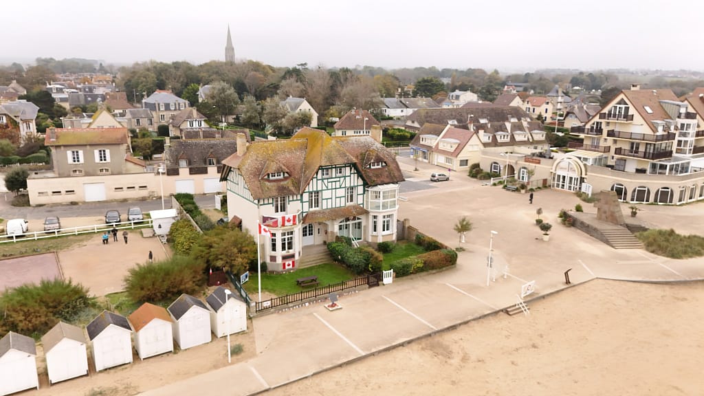
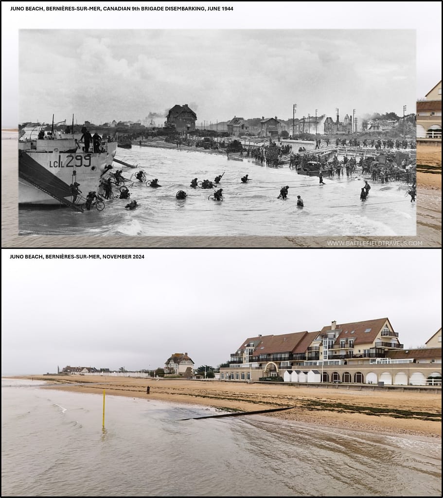
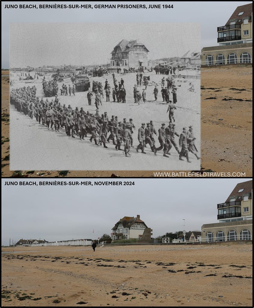
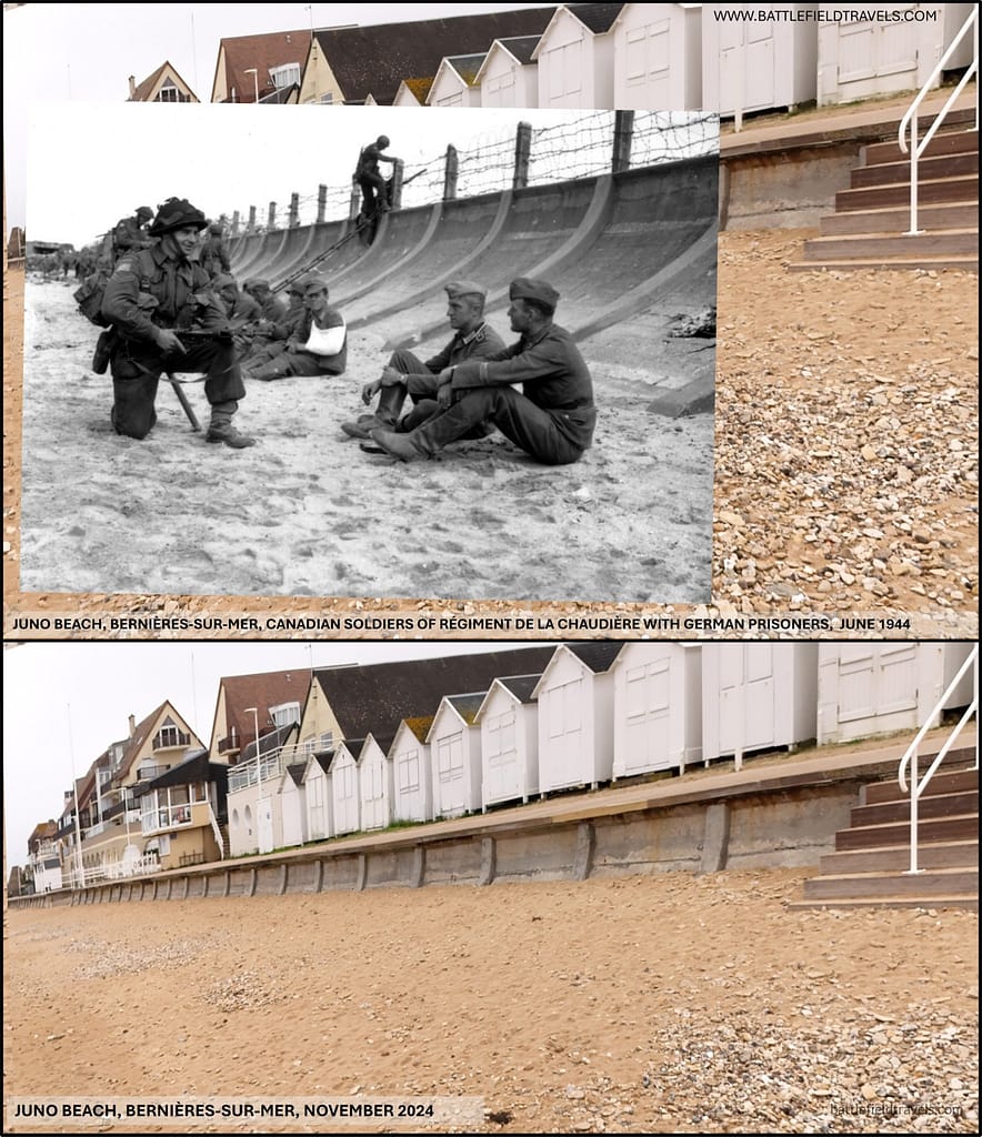
To the east, the 8th Brigade assaulted Nan White and Nan Red. The Queen’s Own Rifles of Canada landed at Bernières-sur-Mer, where a concrete casemate and machine-gun nests swept the beach exits. Casualties were severe in the opening minutes as companies were pinned on the open sand, but surviving tanks and AVREs methodically reduced the strongpoints. By mid-morning, the battalion had broken through and was clearing the town street by street.
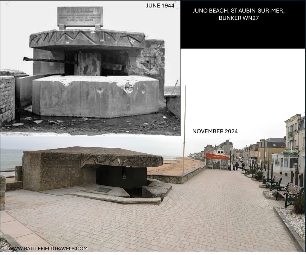
Further east at Saint-Aubin, the North Shore (New Brunswick) Regiment faced a formidable 50 mm anti-tank gun in a reinforced casemate (WN-27), supported by mortars and MG-42s. Several DD tanks were knocked out trying to silence it. The strongpoint held up the assault for hours, inflicting heavy losses until combined infantry, engineers, and armour finally overran the position around midday. Le Régiment de la Chaudière, in reserve, followed up inland once the beachhead was secure, consolidating the advance.20Terry Copp, Fields of Fire: The Canadians in Normandy (2003), pp. 30–36.

Beach exits and early progress
Despite delays and heavy casualties, both brigades eventually secured footholds. By 09:30 hours, assault troops had reached the coastal road in several places. Engineers began clearing minefields and obstacles to open exits for follow-on waves, though congestion and sniper fire slowed progress. Losses were severe: the Queen’s Own Rifles suffered nearly 50% casualties in some companies, while the Winnipeg Rifles and North Shores endured comparable attrition. Yet, the Canadian brigades had achieved their first objective — securing lodgements on the beach and beginning the push inland.21L. F. Ellis, Victory in the West, Vol. I (1962), pp. 160–163.
⚔️ Go deeper — Members get exclusive access to the Deep Research Collection, Field Notes, and monthly Research Dispatches. Try membership free for 7 days, cancel anytime. From $9/month.
Phase 2: Expansion Inland (Late Morning to Afternoon, 6 June)
Courseulles-sur-Mer (Mike Sector, 7th Canadian Infantry Brigade)
By late morning, the Regina Rifles and Royal Winnipeg Rifles had broken through the seawall and were clearing Courseulles-sur-Mer. The town was defended in depth, with firing points cut into garden walls and cellars. Engineers and infantry used bangalore torpedoes and grenades to clear positions, while AVREs and Shermans of the 1st Hussars blasted casemates and fortified houses. Progress was slow, but by 11:30 organised German resistance in the town collapsed. Canadian companies then pressed on towards Graye-sur-Mer and the crossings of the Seulles River.22C.P. Stacey, The Victory Campaign (1960), pp. 75–79.
Bernières-sur-Mer (Nan White, 8th Canadian Infantry Brigade)
To the east, the Queen’s Own Rifles of Canada were fighting into Bernières-sur-Mer. Their assault companies had suffered severe losses in the initial landing, but with support from engineers and surviving Shermans, they reduced the last strongpoints covering the beach exits. By 11:00, resistance along the waterfront had been suppressed, though isolated machine-gun nests and snipers delayed clearance of the inland streets. Once Bernières was secured, Le Régiment de la Chaudière began moving inland to consolidate the position.23Terry Copp, Fields of Fire: The Canadians in Normandy (2003), pp. 37–42.
Saint-Aubin-sur-Mer (Nan Red, 8th Canadian Infantry Brigade)
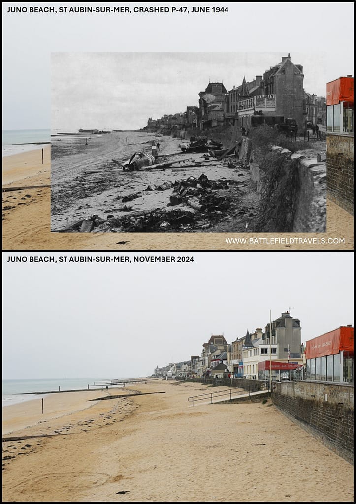
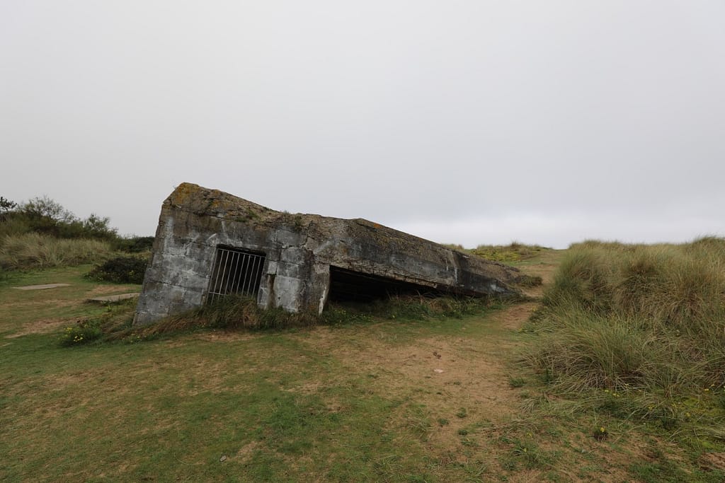
At Saint-Aubin, the North Shore (New Brunswick) Regiment was still heavily engaged around midday. Bunker WN27, a reinforced concrete casemate mounting a 50 mm anti-tank gun, dominated the beach exit and caused heavy losses in the first waves. Engineers laid explosive charges against its embrasure while Shermans fired at point-blank range. The position was eventually destroyed after hours of close fighting, leaving the battalion badly depleted. By early afternoon, Saint-Aubin was secured, although German defenders continued to resist from cellars and side streets.24Max Hastings, Overlord (1984), pp. 132–134.
Langrune-sur-Mer (boundary with Sword Beach)
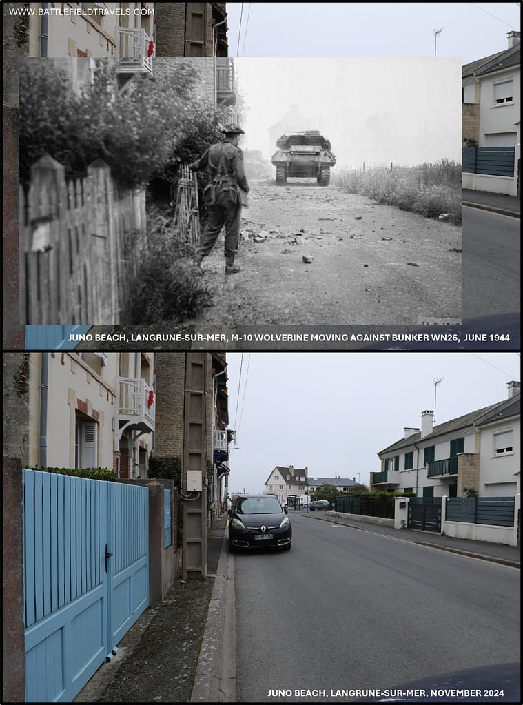
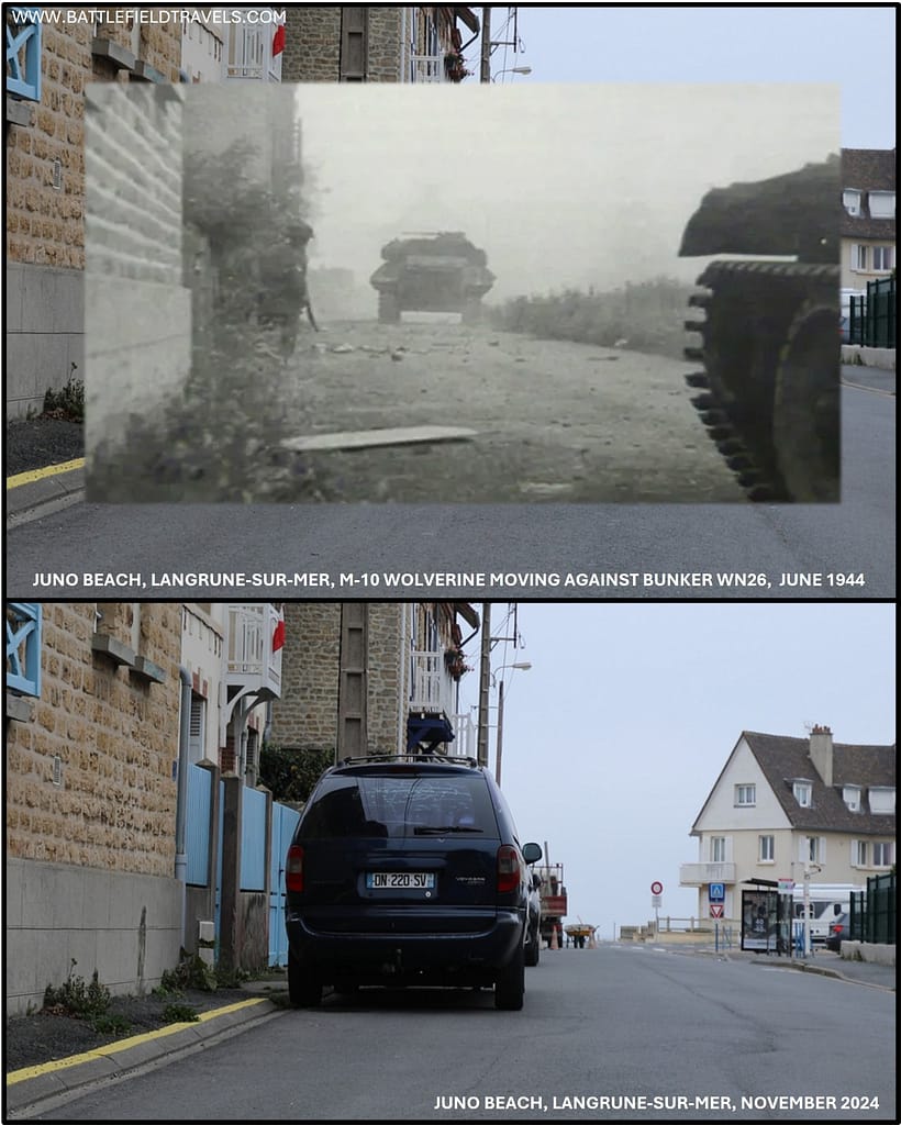
Further east, at Langrune-sur-Mer, 48 Royal Marine Commando was ordered to eliminate the German strongpoint WN26, defended by elements of 9 Kompanie./736 Grenadier Regiment. Initial infantry assaults, supported by Centaur tanks of the Royal Marine Armoured Support Regiment, failed against the reinforced houses and concrete anti-tank wall dominating the seafront. One Centaur exhausted its ammunition without breaching the defences, while another was destroyed on a mine. Mines, wire, and interlocking fire turned the block of houses into a fortress, halting the Marines with heavy casualties.
The attack resumed on 7 June, this time with Canadian M10 tank destroyers and a Sherman in support. Royal Marines employed Bangalore torpedoes to clear mines around the wrecked Centaur, opening a path for the M10s to bring direct fire on the wall. Their high-velocity rounds punched holes through the masonry where the Centaur’s 95 mm HE had failed, and further demolition brought the wall and adjoining houses down. Assault parties forced entry through the gap, clearing the strongpoint house by house. By late morning, WN26 had been overrun and its defenders surrendered, securing Langrune for the commandos and linking Juno and Sword sectors.

German response
Although the beach garrisons had been overrun, elements of the 716. Infanterie-Division continued to resist in isolated positions. Small groups mounted delaying actions in orchards and hedgerows, forcing Canadian companies to fight through at platoon level. The divisional command was effectively paralysed; communications were broken, and Richter had little freedom to manoeuvre his static units. Nevertheless, his surviving companies inflicted steady attrition on the Canadians as they advanced inland.25Niklas Zetterling, Normandy 1944 (2000), pp. 82–85.
Meanwhile, reports of the landings reached 21. Panzer-Division near Caen. During the early afternoon, reconnaissance battalions probed toward the Canadian sector. These movements were delayed by Allied fighter-bombers, which harassed columns on the Caen–Bayeux road. German attempts to coordinate a counter-attack were further slowed by conflicting orders from higher headquarters, which required direct authorisation from OKW before committing panzer reserves. This hesitation gave the Canadians critical time to consolidate their foothold beyond the beaches.26L. F. Ellis, Victory in the West, Vol. I (1962), pp. 163–166.
Phase 3: Inland advance and contact with German reserves (Afternoon–Evening, 6 June)
Canadian advance inland
By mid-afternoon, the 7th and 8th Canadian Brigades were advancing several kilometres inland, moving beyond the coastal belt of villages. Patrols reached the Bayeux–Caen road, one of the division’s primary D-Day objectives. The road represented the first major lateral route inland and was critical for linking the Canadian beachhead with British forces on Gold and Sword. The advance was slowed by congestion at the beach exits, ongoing clearance of minefields, and the fragmented bocage terrain. Companies often fought in isolation, separated by orchards and high hedgerows that limited both visibility and manoeuvre.27C.P. Stacey, The Victory Campaign (1960), pp. 80–83.
Despite these obstacles, progress was steady. Forward elements secured the villages of Banville, Colombiers-sur-Seulles, and Basly, often against only scattered resistance. German rearguards offered local resistance in orchards and crossroads, but lacked cohesion. Canadian artillery units stepped forward to support the infantry advance, while engineer companies cleared routes for tanks and supply vehicles. By 17:00, some battalions had advanced as far as 5–6 kilometres inland.28Terry Copp, Fields of Fire (2003), pp. 43–46.
German counter-moves
The surviving elements of the 716. Infanterie-Division were incapable of mounting a coordinated defence, but 21. Panzer-Division began to move during the afternoon. Reconnaissance detachments advanced toward the Canadian sector, probing for weaknesses around Basly and Anisy. Their movement was disrupted by Allied fighter-bombers, which repeatedly attacked columns on the Caen–Bayeux road. Losses were limited, but the disruption delayed their concentration for a counter-attack.
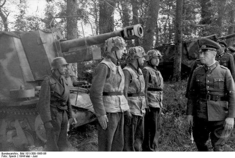
The 21. Panzer-Division commander, Generalleutnant Edgar Feuchtinger, faced conflicting orders. While elements of his division engaged British forces near Sword, he also received instructions to attack the Canadian lodgement. The result was a divided effort. By early evening, a few kampfgruppen had reached the forward Canadian positions, leading to skirmishes on the approaches to Basly and Buron. However, these actions lacked weight and coordination, and were contained by Canadian infantry supported by artillery, and the first Shermans coming inland.29Niklas Zetterling, Normandy 1944 (2000), pp. 86–89.
Phase 4: Evening and aftermath (6 June 1944)
Consolidation of the beachhead
By the evening of D-Day, the 3rd Canadian Infantry Division had secured a continuous beachhead stretching from Courseulles through Bernières to Saint-Aubin. Inland, forward battalions held a line 5–8 kilometres deep, anchored on the Bayeux–Caen road in several places. The Canadians had not taken Caen as planned, but they had denied the Germans the ability to mount an organised counter-attack against the beaches.30C.P. Stacey, The Victory Campaign (1960), pp. 83–86.
Preparing for German counterattacks
German counterattacks from 21. Panzer-Division failed to dislodge the Canadians. Isolated actions near Basly and Buron were contained by combined infantry, armour, and artillery fire. Allied airpower further limited German mobility; fighter-bombers harassed any attempts to concentrate forces during daylight. By nightfall, Canadian units were consolidating defensive positions, linking up with British forces on their flanks, and preparing for renewed German resistance on 7 June.31Niklas Zetterling, Normandy 1944 (2000), pp. 88–91.
Outcomes and Significance
Results
The assault on Juno Beach achieved its essential objectives. The 3rd Canadian Infantry Division successfully forced a landing, secured the coastal villages, and advanced to the Bayeux–Caen road in several places. Although Caen remained in German hands, the Canadians linked with the British on Gold and Sword, establishing a continuous Allied front across the eastern sector of the invasion.32C.P. Stacey, The Victory Campaign (1960), pp. 86–88.
Canadian losses
Casualties were severe. Canadian losses on D-Day totalled over 1,000 men killed, wounded, or missing — proportionally higher than any other Allied beach. Losses were particularly severe in the first assault waves: the Queen’s Own Rifles and Royal Winnipeg Rifles both suffered near 50% casualties in some companies, while the North Shore Regiment lost over a third of its strength. Armour also paid a high price, with the 1st Hussars losing nearly half of their Sherman DDs.33Terry Copp, Fields of Fire (2003), pp. 46–48..
The scale of attrition reflected the strength of the German defences and the later landing hour, which exposed the assaulting waves to well-prepared and alert defenders in full daylight. Nevertheless, the Canadians displayed resilience under fire, pressing inland even as first-wave battalions were reduced to fragments.34Terry Copp, Fields of Fire (2003), pp. 48–51.
German losses
German forces suffered also heavy losses in men and materiel. The 716. Infanterie-Division was effectively shattered as a coherent formation, with many positions destroyed or bypassed. Counter-attacks by 21. Panzer-Division were piecemeal and failed to regain lost ground. The inability to launch a coordinated, immediate counter-attack was decisive; Allied air supremacy, naval firepower, and German command hesitation combined to prevent an organised response.35Niklas Zetterling, Normandy 1944 (2000), pp. 91–93.
The Juno Beach battlefield today
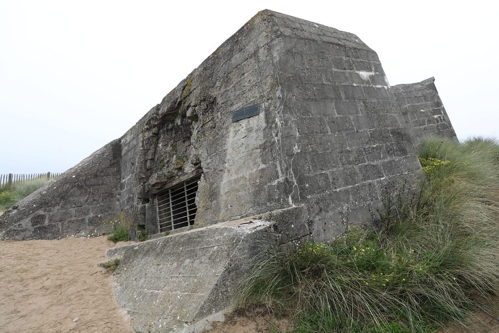
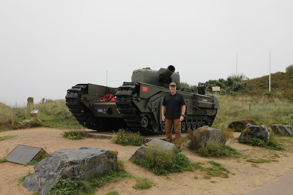
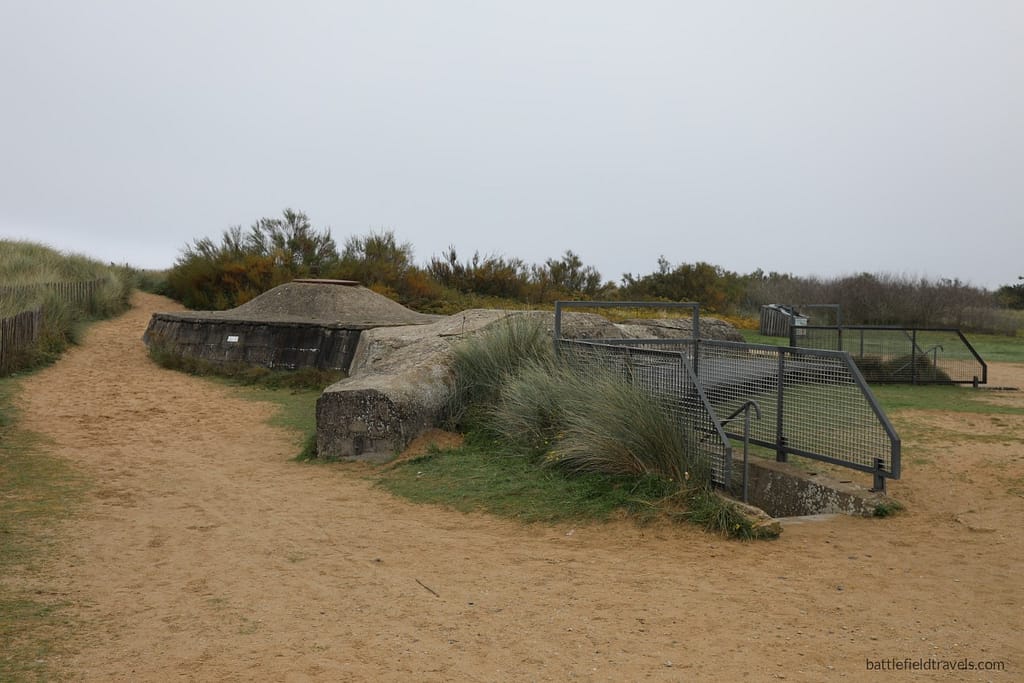
The Juno Beach sector remains one of the most accessible and best-preserved of the Normandy landing sites. The towns of Courseulles, Bernières, and Saint-Aubin still retain many wartime structures, including casemates, bunkers, and fortified houses that formed the German Widerstandsnester. Several have been preserved or marked with plaques and memorials. The long tidal flats, seawalls, and coastal road remain much as they were in 1944, allowing a clear impression of the terrain faced by the assault troops.36Tim Saunders, Juno Beach: 3rd Canadian Infantry Division’s Battle of D-Day (Barnsley: Pen & Sword, 2004), pp. 15–18.
Juno Beach Centre
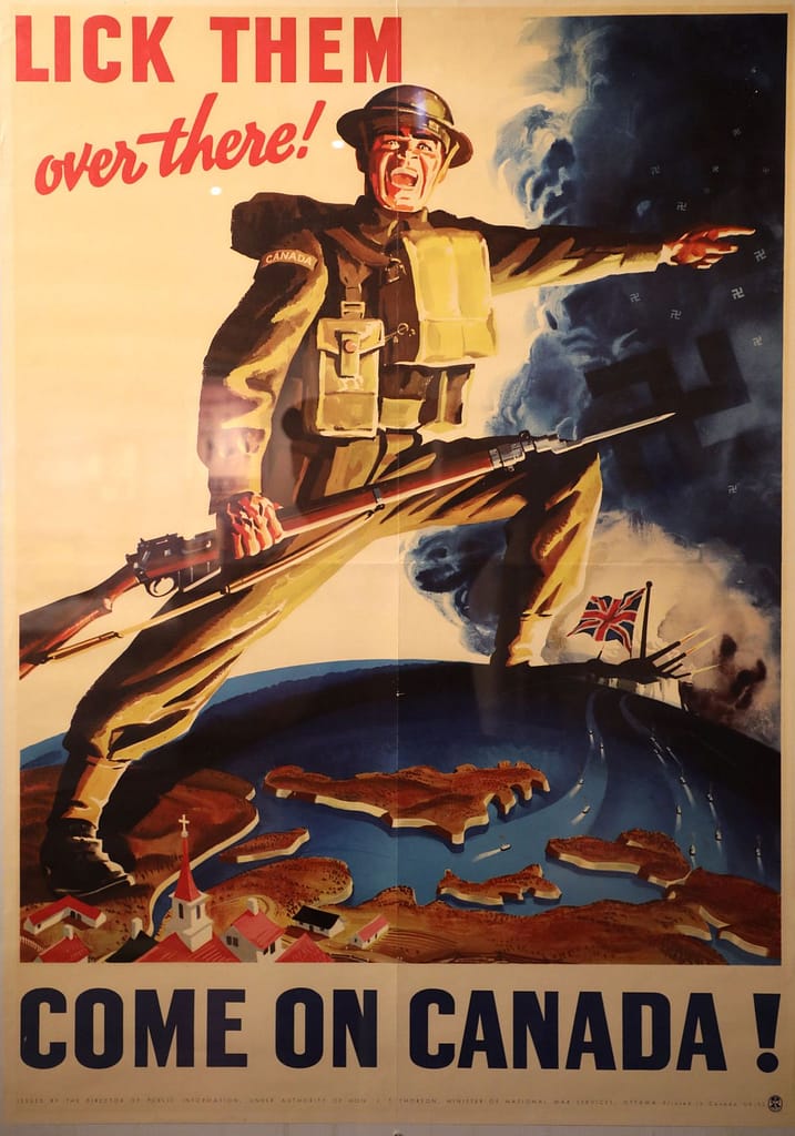
The focal point for visitors is the Juno Beach Centre at Courseulles-sur-Mer, established in 2003 as the Canadian museum of the Normandy landings. The centre provides exhibitions on the 3rd Canadian Division, the wider campaign, and Canada’s role in the Second World War. A preserved bunker complex nearby forms part of the tour, enabling visitors to understand the nature of the German defences.37Juno Beach Centre Association, “The Juno Beach Centre,” accessed Aug 2025.

Canada House
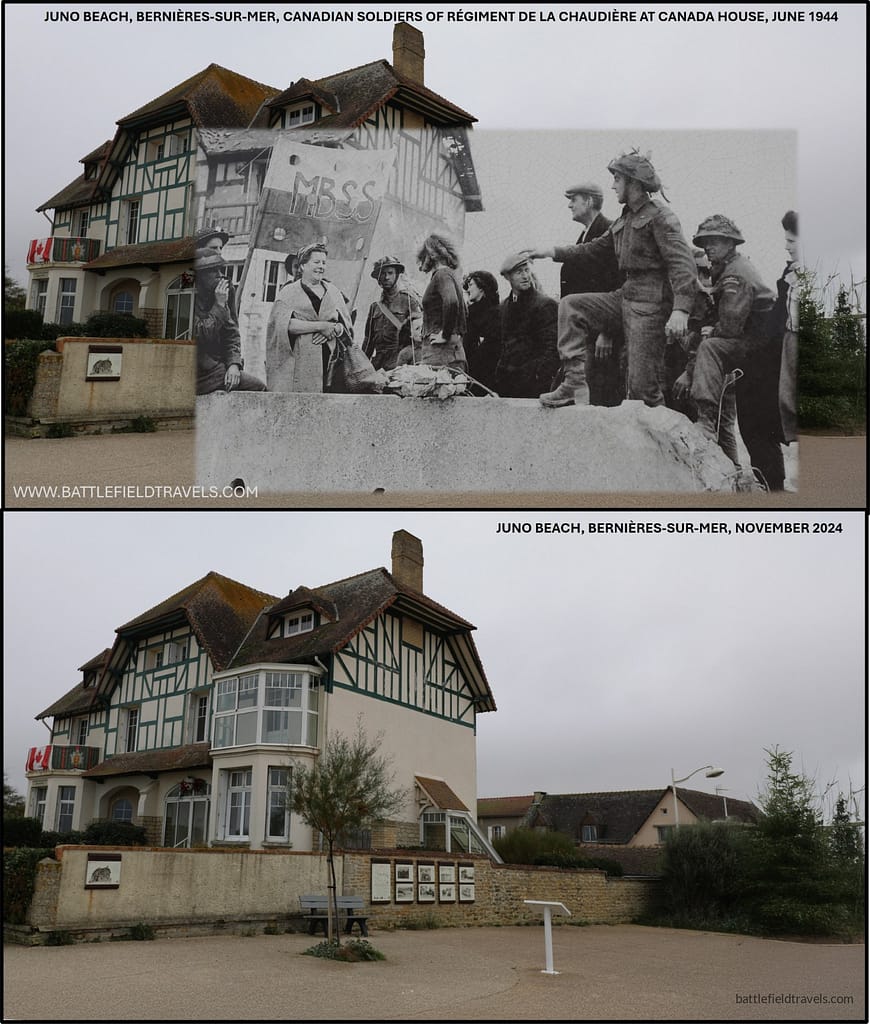
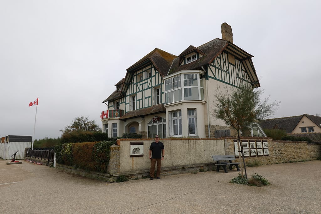
At Bernières-sur-Mer, the famous house on the seafront — one of the first liberated in the sector by the Queen’s Own Rifles — still stands, marked with commemorative plaques. In Saint-Aubin, the massive 50 mm casemate that held up the assault remains in place, a stark reminder of the resistance faced by the North Shore Regiment. Inland, roads leading to Banville, Basly, and Buron follow the same lines along which the Canadians advanced on D-Day.38Georges Bernage, Battle of the Beaches: Normandy 1944 (Bayeux: Heimdal, 1994), pp. 56–59.
For anyone exploring the battlefield, the Canadian memorials, cemeteries, and interpretation centres create a strong sense of the scale of sacrifice endured. The terrain — from the tidal flats and seawalls to the bocage inland — still illustrates the challenges of the assault. Juno remains both a place of commemoration and an essential study ground for understanding the Canadian contribution to the Normandy landings.39Copp, Fields of Fire (2003), pp. 200–204.
Additional Images of Juno Beach
360 image, Canada House at Bernieres-sur-Mer
Found this useful? Buy me a coffee — it helps fund future battlefield research


Authored by Mick Prictor, a retired military officer with 40 years’ service, and a military historian specialising in terrain-focused analysis of tactics, doctrine, and command decision-making in land warfare. His work draws on extensive battlefield fieldwork—more than 280 sites worldwide—and one of the world’s largest private collections of historic military arms, uniforms, and equipment. About me
❓ Test Your D-Day Knowledge
Twenty questions covering the airborne operations, invasion beaches, commanders, forces and fighting of 6 June 1944.
20 questions · 60% to pass · expect a challenge
📚 Notes and References
Notes
- 1Max Hastings, Overlord: D-Day and the Battle for Normandy (London: Michael Joseph, 1984), pp. 29–33. ↩︎
- 2Carlo D’Este, Decision in Normandy (London: Collins, 1983), pp. 45–50. ↩︎
- 3C.P. Stacey, The Victory Campaign: The Operations in North-West Europe 1944–1945 (Ottawa: Queen’s Printer, 1960), pp. 58–63. ↩︎
- 4Stephen Ambrose, D-Day: June 6, 1944 (New York: Simon & Schuster, 1994), pp. 228–233. ↩︎
- 5John Buckley, Monty’s Men: The British Army and the Liberation of Europe (New Haven: Yale University Press, 2013), pp. 85–87. ↩︎
- 6C.P. Stacey, The Victory Campaign (1960), pp. 58–63. ↩︎
- 7Terry Copp, Fields of Fire: The Canadians in Normandy (2003), pp. 22–26. ↩︎
- 8L. F. Ellis, Victory in the West, Vol. I (1962), pp. 150–156. ↩︎
- 9Max Hastings, Overlord (1984), pp. 123–127. ↩︎
- 10Niklas Zetterling, Normandy 1944 (2000), pp. 80–84. ↩︎
- 11Stacey, The Victory Campaig, pp. 60–63. ↩︎
- 12Zetterling, Normandy 1944, pp. 80–84. ↩︎
- 13C.P. Stacey, The Victory Campaign: The Operations in North-West Europe 1944–1945 (Ottawa: Queen’s Printer, 1960), pp. 64–68. ↩︎
- 14Terry Copp, Fields of Fire: The Canadians in Normandy (Toronto: University of Toronto Press, 2003), pp.27–30. ↩︎
- 15Stephen Ambrose, D-Day, June 6, 1944 (New York: Simon & Schuster, 1994), pp. 233–236. ↩︎
- 16C.P. Stacey, The Victory Campaign (Ottawa: Queen’s Printer, 1960), pp. 69–71. ↩︎
- 17L. F. Ellis, Victory in the West, Vol. I: The Battle of Normandy (London: HMSO, 1962), pp. 156–160. ↩︎
- 18Stephen Ambrose, D-Day, June 6, 1944 (New York: Simon & Schuster, 1994), pp. 239–241. ↩︎
- 19C.P. Stacey, The Victory Campaign (1960), pp. 72–75. ↩︎
- 20Terry Copp, Fields of Fire: The Canadians in Normandy (2003), pp. 30–36. ↩︎
- 21L. F. Ellis, Victory in the West, Vol. I (1962), pp. 160–163. ↩︎
- 22C.P. Stacey, The Victory Campaign (1960), pp. 75–79. ↩︎
- 23Terry Copp, Fields of Fire: The Canadians in Normandy (2003), pp. 37–42. ↩︎
- 24Max Hastings, Overlord (1984), pp. 132–134. ↩︎
- 25Niklas Zetterling, Normandy 1944 (2000), pp. 82–85. ↩︎
- 26L. F. Ellis, Victory in the West, Vol. I (1962), pp. 163–166. ↩︎
- 27C.P. Stacey, The Victory Campaign (1960), pp. 80–83. ↩︎
- 28Terry Copp, Fields of Fire (2003), pp. 43–46. ↩︎
- 29Niklas Zetterling, Normandy 1944 (2000), pp. 86–89. ↩︎
- 30C.P. Stacey, The Victory Campaign (1960), pp. 83–86. ↩︎
- 31Niklas Zetterling, Normandy 1944 (2000), pp. 88–91. ↩︎
- 32C.P. Stacey, The Victory Campaign (1960), pp. 86–88. ↩︎
- 33Terry Copp, Fields of Fire (2003), pp. 46–48. ↩︎
- 34Terry Copp, Fields of Fire (2003), pp. 48–51. ↩︎
- 35Niklas Zetterling, Normandy 1944 (2000), pp. 91–93. ↩︎
- 36Tim Saunders, Juno Beach: 3rd Canadian Infantry Division’s Battle of D-Day (Barnsley: Pen & Sword, 2004), pp. 15–18. ↩︎
- 37Juno Beach Centre Association, “The Juno Beach Centre,” accessed Aug 2025. ↩︎
- 38Georges Bernage, Battle of the Beaches: Normandy 1944 (Bayeux: Heimdal, 1994), pp. 56–59. ↩︎
- 39Copp, Fields of Fire (2003), pp. 200–204. ↩︎
Resources & References
Primary & Official Histories
- L. F. Ellis, Victory in the West, Vol. I: The Battle of Normandy (London: HMSO, 1962).
- C. P. Stacey, The Victory Campaign: The Operations in North-West Europe, 1944–45 (Ottawa: Queen’s Printer, 1960).
- War Diaries, 3rd Canadian Infantry Division & 7th, 8th Brigades, Library and Archives Canada.
- Naval Staff Histories, Operation Neptune, Admiralty Records, The National Archives (UK).
- RAF Second Tactical Air Force Operations Records, The National Archives (UK).
Secondary Sources (Cited in Footnotes)
- War Diaries, 50th (Northumbrian) Division & 231, 69, 151 Brigades, The National Archives (UK).
- Naval Staff Histories, Operation Neptune, Admiralty Records.
- RAF Second Tactical Air Force Operations Records, The National Archives (UK).
Secondary Sources (Cited in Footnotes)
- Ambrose, S. E. (1999). D-day, June 6, 1944: the climactic battle of World War II. Thorndike.
- Beevor, Antony. (2009). D-Day: The Battle for Normandy. Penguin Books
- Ryan, Cornelius (1959). The Longest Day: June 6, 1944. Simon and Schuster, New York.
- Hastings, Max (1984). Overlord : D-Day and the battle for Normandy. Simon and Schuster, New York.
- Georges Bernage, D-Day Landing Beaches: The Guide (Bayeux: Heimdal, 2009).
- John Buckley, Monty’s Men: The British Army and the Liberation of Europe, 1944–45 (New Haven: Yale University Press, 2013).
- Niklas Zetterling, Normandy 1944: German Military Organisation, Combat Power and Organisational Effectiveness (Winnipeg: J.J. Fedorowicz, 2000).
- Ken Ford, D-Day 1944 (4) Gold & Juno Beaches (Osprey 2002)
- Terry Copp, Fields of Fire: The Canadians in Normandy (Toronto: University of Toronto Press, 2003).
Recommended Additional Works
- Carlo D’Este, Decision in Normandy (London: Collins, 1983).
- Chester Wilmot, The Struggle for Europe (London: Collins, 1952).
- Michael Reynolds, Steel Inferno: I SS Panzer Corps in Normandy (New York: Sarpedon, 1997).
- David French, Raising Churchill’s Army: The British Army and the War against Germany 1919–45 (Oxford: Oxford University Press, 2000).
Cartography & Terrain Analysis
- GSGS 4347 series 1:50,000 Normandy maps (Allied issue, 1944).
- IGN (Institut Géographique National) aerial overlays of Normandy coast.
- Google Earth Pro terrain analysis for Juno sector (tidal flats, seawall, bocage inland).
- Battlefield overlays and site surveys, author’s fieldwork (Courseulles–Bernières–Saint-Aubin sectors).
📚 Further Reading
This battle study nests within the broader analytical framework explored in the Research Hub, where operational methods, operating environments, armies, commanders, and weapons are examined across conflicts and eras. The links below connect related studies across the wider body of battlefield analysis on the BattlefieldTravels site.
⚔️ Explore all battle studies from World War Two 1939-1945
🏛️Explore the museum of World War Two historic artefacts
The book list for this conflict includes the leading campaign studies, memoirs, and operational analyses of the D-Day landings, selected specifically to complement this battlefield study.
📚World War Two – Recommended Reading
🗞️ For updates on new battlefield studies and research insights, you can subscribe to the Newsletter.
Related Battle Studies, Museum Pieces & Reading Resources
 ⚔️ D-Day: Brecourt Manor assault, Easy Company, 506th PIR,
6 June 1944
 ⚔️ D-Day: Sword Beach landings,
6 June 1944
 ⚔️ D-Day: Utah Beach landings,
6 June 1944
 ⚔️ D-Day: Omaha Beach landings,
6 June 1944
 📝 🔒Field Note: XXX Corps Orders, Leopoldsburg, Belgium, 15 Sep 1944
 ⚔️ D-Day: Gold Beach landings,
6 June 1944
🧭 Battlefield Travel Guide: Juno Beach
Getting There
- Nearest Towns: Courseulles-sur-Mer (centre of the sector), Bernières-sur-Mer (east), Saint-Aubin-sur-Mer (far east).
- Access: From Caen (~20 km), follow D7/D79 to Courseulles. The D514 coast road links all Juno localities.
- Parking: Public lots at the Juno Beach Centre and along seafronts in Courseulles, Bernières, and Saint-Aubin.
Site Orientation
- Key Landmarks: Juno Beach Centre (museum), Canada House at Bernières, DD Sherman memorial in Courseulles, bunkers of Widerstandsnester (WN) positions, and inland strongpoints.
- Best Vantage Points: Dune tops and seawalls at Courseulles/Bernières for beach perspective; inland at Bény-sur-Mer for ground overlooking the exits.
- Walking Routes: Seafront promenades connect interpretation panels; inland walks trace German strongpoints and Canadian advance routes.
Museums & Visitor Centres
- On-site: Juno Beach Centre (Courseulles) — comprehensive museum on Canada’s D-Day and Normandy campaign; guided bunker tours seasonally.
- Nearby: Bény-sur-Mer Canadian War Cemetery; local communes maintain outdoor displays and plaques across the sector.
On-Site Experience
- Interpretive Signage: Multilingual panels mark unit sectors, beach obstacles, and German WN positions; QR-linked content near the Centre.
- Atmosphere: Broad, flat beaches with low dunes; at low tide the tidal flat emphasises the distance Canadian infantry crossed under fire.
Nearby Points of Interest
- Related Sites: Arromanches (Mulberry B remnants) to the west; Pegasus Bridge & Ranville to the east for 6th Airborne context.
- Local: Courseulles harbour and fish market; Bernières seafront villas including Canada House; Saint-Aubin coastal gun casemates.
Practical Tips
- When to Visit: Early morning/late afternoon for photography; commemorations and reenactments cluster around 6 June.
- Facilities: Cafés, restrooms, and shops in each town; the Juno Beach Centre has a café/bookshop and seasonal guided tours.
- Notes: Low tide reveals more obstacle locations; wind can be strong — dress for coastal conditions.
Subscribe to Battlefield Travels and receive a free E-Book Battlefield Guide
Unlock expert battlefield analysis, campaign reconstructions, and historical insights drawn from firsthand exploration and primary sources.
🗺️ You’ll receive:
🎖️ Exclusive historical insights you won’t find elsewhere
📘 A free eBook: 10 Tips for Exploring Historic Battlefields
📰 New battlefield studies straight to your inbox as they are published

⚔️ Go deeper — Members get exclusive access to the Deep Research Collection, Field Notes, and monthly Research Dispatches. Try membership free for 7 days, cancel anytime. From $9/month.